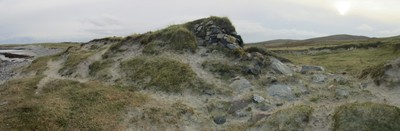
This settlement is mentioned as early as 1429, and was cleared in the late 1820s. There are the foundations for at least eighteen buildings in the area centred at NF 7426 7630. They range from 11x5m to 4.5x3m and are associated with an enclosure. The majority are bounded by turf covered walls, the best preserved standing to a height of 1m in 1965. Thirteen unroofed buildings and two enclosures are depicted on the 1st edition OS map. Seven unroofed buildings and an enclosure are shown on the current OS map. The group of roundhouses at Foshigarry has in part been washed away by the sea and is partly beneath the ruins of the recent village. Excavated between 1914 and 1919. Pottery dated to the 4th century was found on the nearby beach. A building at NF 74305 76271 is eroding out of the coastal section, possibly quite fresh erosion as the stone work does not appear to be too weathered. Other areas can be seen eroding out of section including a small section of possible wall quite low in the section suggesting an earlier phase of occupation. There is a freshly cut drainage channel running through this area and there is a lot of rabbit burrowing damage to the monument.
ShoreUPDATE 03/12/2015
The building at NF 74305 76271 can be identified (see image) and the coastal slope in the immediate vicinity seems to have established vegetation on its face and does not appear to be actively eroding. The coastline to the east of this location is eroding, though it seems to be mainly from wind and particularly stock damage rather than the sea. This is particularly evident near the drainage channel referred to where a former enclosure or sea defence wall right on the dune edge looks as if it is suffering damage.
Location
74260.00
876300.00
27700
57.6583061
-7.4639621
Submitted photographs
Image
Date
Caption
User
03/12/2015
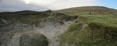
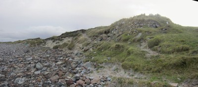
Erosion near drainage channel
DavidNewman
03/12/2015
Erosion near drainage channel
DavidNewman
03/12/2015
Building at NF 74305 76271
DavidNewman
Submitted updates
Update id
Date
User
2292
03/12/2015
DavidNewman
Tidal state
Mid
Site located?
Yes
Proximity to coast edge
Coast edge
Coastally eroding?
active sea erosion; active wind erosion (in dunes only); has eroded in the past
Threats
stock erosion; animal burrows
Visibility above ground
Highly visible (substantial remains)
Visibility in section
Limited visibility in section
Access
accessible on foot (no footpath)
Local knowledge
has local associations/history
Description
This settlement is mentioned as early as 1429, and was cleared in the late 1820s. There are the foundations for at least eighteen buildings in the area centred at NF 7426 7630. They range from 11x5m to 4.5x3m and are associated with an enclosure. The majority are bounded by turf covered walls, the best preserved standing to a height of 1m in 1965. Thirteen unroofed buildings and two enclosures are depicted on the 1st edition OS map. Seven unroofed buildings and an enclosure are shown on the current OS map. The group of roundhouses at Foshigarry has in part been washed away by the sea and is partly beneath the ruins of the recent village. Excavated between 1914 and 1919. Pottery dated to the 4th century was found on the nearby beach. A building at NF 74305 76271 is eroding out of the coastal section, possibly quite fresh erosion as the stone work does not appear to be too weathered. Other areas can be seen eroding out of section including a small section of possible wall quite low in the section suggesting an earlier phase of occupation. There is a freshly cut drainage channel running through this area and there is a lot of rabbit burrowing damage to the monument.
ShoreUPDATE 03/12/2015
The building at NF 74305 76271 can be identified (see image) and the coastal slope in the immediate vicinity seems to have established vegetation on its face and does not appear to be actively eroding. The coastline to the east of this location is eroding, though it seems to be mainly from wind and particularly stock damage rather than the sea. This is particularly evident near the drainage channel referred to where a former enclosure or sea defence wall right on the dune edge looks as if it is suffering damage.
Retain high priority. Regular monitoring. Detailed survey, attempt to relate features visible in section to results of excavation. Suggest controlling stock access to eroding areas.
Comments
Without access to original survey images it is not possible to assess the true extent of any ongoing erosion here. However, the building at NF 74305 76271 can be identified (see image) and the coastal slope in the immediate vicinity seems to have established vegetation on its face and does not appear to be actively eroding. The coastline to the east of this location is eroding, though it seems to be mainly from wind and particularly stock damage rather than the sea. This is particularly evident near the drainage channel referred to where a former enclosure or sea defence wall right on the dune edge looks as if it is suffering damage.