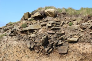
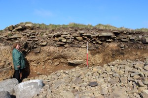
(i) A grassy mound, 15m in diameter and 1.5m high, is located some 20m from the coast edge. (ii) On the coast, archaeological deposits have been exposed in section by coastal erosion. The erosion face extends for 16m and is up to 1.3m deep. A concentration of horizontally-set slabs towards the base of the section, which cover an OGS, may represent a surface. To the north of this, fragments of a structure are associated with an anthropogenic soil, containing charcoal and peatash. Further north again, a probable heath setting is exposed in section; the soil deposits contain inclusions of peatash and burnt bone.
21/04/2014
Dry stone structural remains extend over a 20m stretch of coast edge.
These comprise from the north: a mound or bank with a stone core, possibly a section through a wall; a stretch of concentrated stone, mush of it horizontally laid, possible representing further walling; and what appears to be a rectangular cut possibly lined and filled with stone with evidence of in situ burning. The burnt area also contains frequent nodules of iron. Iron pan was observed in other parts of the section, so this could be naturally precipitated iron pan. However, the concentration in the burnt area could indicate it is is metal working debris.
Location
362514.00
1039285.00
27700
59.2384758
-2.6587582
Submitted photographs
Image
Date
Caption
User
21/04/2014
Detail of rectangular feature with burning
training1
21/04/2014
Detail of section through possible wall, north end of section
training1
21/04/2014
Overview of section, looking east
training1
21/04/2014
Showing north end of exposure in relation to end of modern field boundary wall, looking northeast
training1
21/04/2014
General situaltion of coastal exposure, looking north
training1
Submitted updates
Update id
Date
User
1687
21/04/2014
training1
Tidal state
Mid
Site located?
Yes
Proximity to coast edge
Coast edge
Coastally eroding?
active sea erosion; has eroded in the past
Visibility above ground
Not visible
Visibility in section
Clearly visible in section
Access
accessible on foot (no footpath)
Local knowledge
don't know
Description
(i) A grassy mound, 15m in diameter and 1.5m high, is located some 20m from the coast edge. (ii) On the coast, archaeological deposits have been exposed in section by coastal erosion. The erosion face extends for 16m and is up to 1.3m deep. A concentration of horizontally-set slabs towards the base of the section, which cover an OGS, may represent a surface. To the north of this, fragments of a structure are associated with an anthropogenic soil, containing charcoal and peatash. Further north again, a probable heath setting is exposed in section; the soil deposits contain inclusions of peatash and burnt bone.
21/04/2014
Dry stone structural remains extend over a 20m stretch of coast edge.
These comprise from the north: a mound or bank with a stone core, possibly a section through a wall; a stretch of concentrated stone, mush of it horizontally laid, possible representing further walling; and what appears to be a rectangular cut possibly lined and filled with stone with evidence of in situ burning. The burnt area also contains frequent nodules of iron. Iron pan was observed in other parts of the section, so this could be naturally precipitated iron pan. However, the concentration in the burnt area could indicate it is is metal working debris.
Clean, record and sample for dating and for evidence of metal working activity.
These remains are very possibly related to earthwork banks, enclosures and walling in the vicinity. Sites: 12773, 12774 and 6769.
Survey all features and look at their relationship.
Reassign priority 1