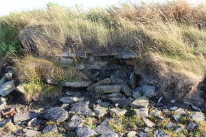
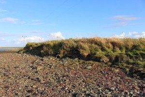
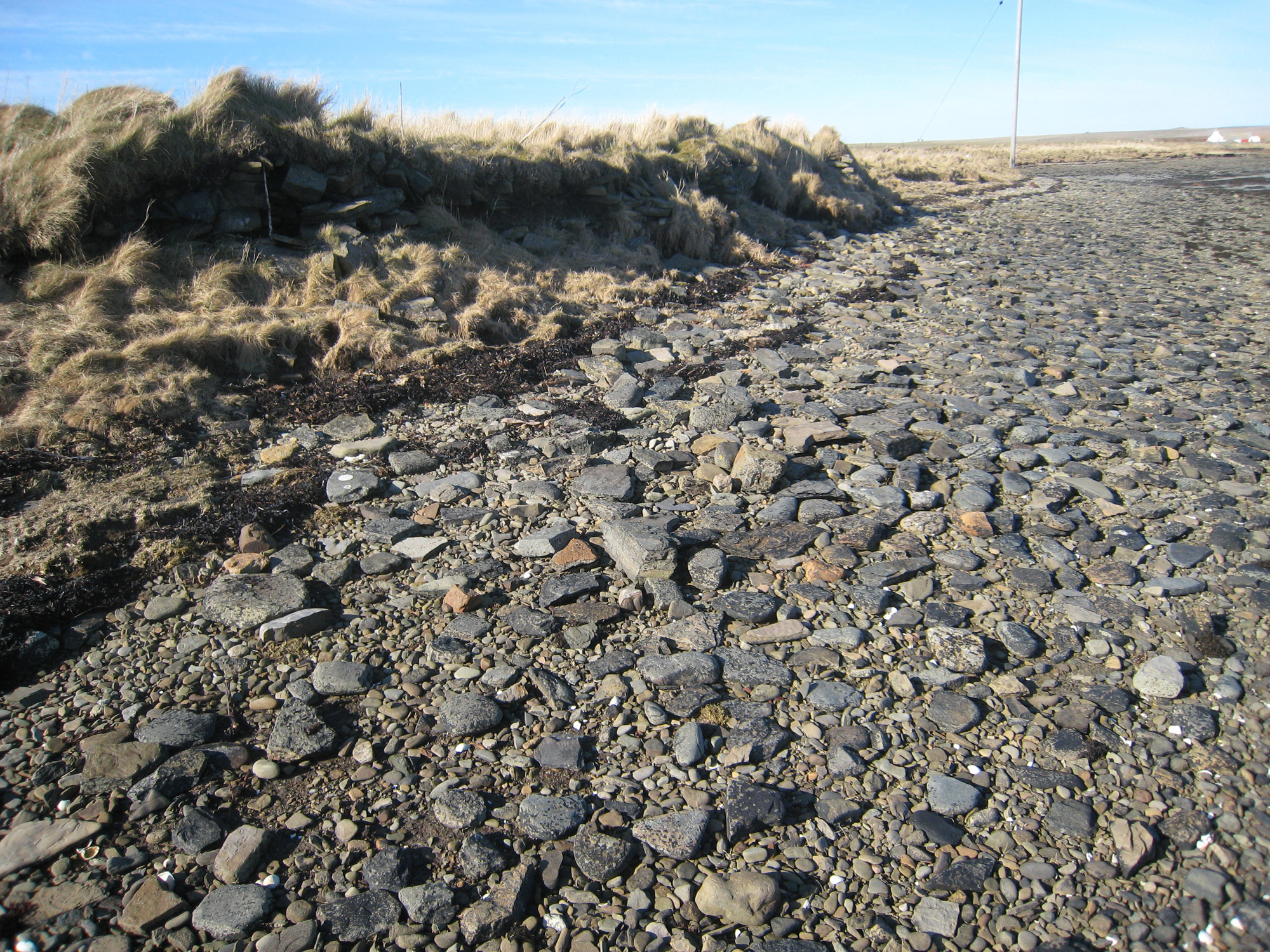
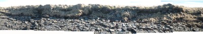
Three fragments of walling are exposed in a coastal section along Ouse Point: a narrow strip of land which extends between Kettletoft Bay and its inner bay, the Peerie Sea. The walling is coursed and stands up to 0.5m/5 courses high. Two of the wall fragments, which protrude from the section face at oblique angles, appear to represent the side and end walls of a rectangular structure with the corner already destroyed by the sea. The third fragment of walling protrudes at a right angle from the section and may be part of an internal dividing wall. On this assumption, the building measures at least 20m in length. Floor levels are suggested by successive layers of flat slabs, interspersed with grey clay and fine gravel. Associated soil deposits contain inclusions of animal bone, shell and mortar. The possible date range for this structure ranges from the Norse to post-medieval periods.
Sections of the wall are being washed out. In 2012 4 large magnetite ore lumps found falling out of wall back face. May be boat noust to south.
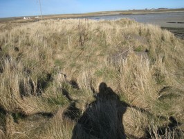
Outline of rectangular building visible as earthworks above ground. Three patches of stonework visible in the section. The westernmost area is all that remains of the north wall, the rest of the north elevation has been eroded out. The middle and eastern areas of stone possibly represent an internal wall and the east wall. All stand to around 0.5m high and around 5-6 courses are visible, with clay bonding.
CP- site visited with 'Kirkhall' after she found several lumps of magnetite on the foreshore in the general vicinity. More lumps identified on the site. These immediately underlie turf and overlie the uppermost remains of a wall. The landward side of the site was very overgrown and hard to interpret.
Location
367149.00
1039479.00
27700
59.2406044
-2.5775561
Submitted photographs
Image
Date
Caption
User
03/08/2018
August 2018: possible floor levels in eroding coast edge
joannahambly
03/08/2018
August 2018: general view of coast edge showing new poles on top of site
joannahambly
03/08/2018
August 2018: Stonework visible in coast edge
joannahambly
26/05/2013
Site in March 2016, looking SW
joannahambly
25/04/2013
behind site
kirkhall
25/04/2013
ouse wide
kirkhall
25/04/2013
ouse long
kirkhall
26/08/2013
Coastal exposure. Lumps of magnetite are located immediately to right of trowel.
cparker
26/08/2013
Panorama photo3
cparker
26/08/2013
panorama photo 2
cparker
26/05/2013
General view, panorama of coastal exposure with photo 2 and 3.
cparker
Submitted updates
Update id
Date
User
3339
03/08/2018
EllieSCHARP
Description
ShoreUPDATE August 2018
Largely as described
Section appears vegetated and generally stable.
Recently erected electricity pylons have been inserted into the structure in the hinterland immediately behind the coast edge. This has likely compromised archaeological remains
1225
26/05/2013
cparker
Tidal state
Low
Site located?
Yes
Proximity to coast edge
Coast edge
Coastally eroding?
active sea erosion
Threats
none
Visibility above ground
Limited visibility (partial remains)
Visibility in section
Clearly visible in section
Access
accessible - difficult terrain
Local knowledge
don't know
Description
Three fragments of walling are exposed in a coastal section along Ouse Point: a narrow strip of land which extends between Kettletoft Bay and its inner bay, the Peerie Sea. The walling is coursed and stands up to 0.5m/5 courses high. Two of the wall fragments, which protrude from the section face at oblique angles, appear to represent the side and end walls of a rectangular structure with the corner already destroyed by the sea. The third fragment of walling protrudes at a right angle from the section and may be part of an internal dividing wall. On this assumption, the building measures at least 20m in length. Floor levels are suggested by successive layers of flat slabs, interspersed with grey clay and fine gravel. Associated soil deposits contain inclusions of animal bone, shell and mortar. The possible date range for this structure ranges from the Norse to post-medieval periods.
Sections of the wall are being washed out. In 2012 4 large magnetite ore lumps found falling out of wall back face. May be boat noust to south.
Outline of rectangular building visible as earthworks above ground. Three patches of stonework visible in the section. The westernmost area is all that remains of the north wall, the rest of the north elevation has been eroded out. The middle and eastern areas of stone possibly represent an internal wall and the east wall. All stand to around 0.5m high and around 5-6 courses are visible, with clay bonding.
CP- site visited with 'Kirkhall' after she found several lumps of magnetite on the foreshore in the general vicinity. More lumps identified on the site. These immediately underlie turf and overlie the uppermost remains of a wall. The landward side of the site was very overgrown and hard to interpret.
Geophysical survey, plane table survey when vegetation dies back. Further investigation into the significance of the occurrence of magnetite.
933
25/04/2013
kirkhall
Tidal state
Low
Site located?
Yes
Proximity to coast edge
Coast edge
Coastally eroding?
active sea erosion
Threats
none
Visibility above ground
Not visible
Visibility in section
Clearly visible in section
Access
easily accessible - no restrictions; vehicular access; accessible on foot (no footpath)
Local knowledge
is not locally known
Description
Three fragments of walling are exposed in a coastal section along Ouse Point: a narrow strip of land which extends between Kettletoft Bay and its inner bay, the Peerie Sea. The walling is coursed and stands up to 0.5m/5 courses high. Two of the wall fragments, which protrude from the section face at oblique angles, appear to represent the side and end walls of a rectangular structure with the corner already destroyed by the sea. The third fragment of walling protrudes at a right angle from the section and may be part of an internal dividing wall. On this assumption, the building measures at least 20m in length. Floor levels are suggested by successive layers of flat slabs, interspersed with grey clay and fine gravel. Associated soil deposits contain inclusions of animal bone, shell and mortar. The possible date range for this structure ranges from the Norse to post-medieval periods.
Sections of the wall are being washed out. In 2012 4 large magnetite ore lumps found falling out of wall back face. May be boat noust to south.
Survey to establish extent of site. Sampling.
Comments
This is a rapidly eroding vulnerable site, despite being in a sheltered inner sea area.
932
24/04/2013
EllieSCHARP
Tidal state
Low
Site located?
Yes
Proximity to coast edge
Coast edge
Coastally eroding?
active sea erosion; has eroded in the past
Threats
animal burrows
Visibility above ground
Limited visibility (partial remains)
Visibility in section
Clearly visible in section
Access
easily accessible - no restrictions; accessible on foot (no footpath)
Local knowledge
don't know
Description
Three fragments of walling are exposed in a coastal section along Ouse Point: a narrow strip of land which extends between Kettletoft Bay and its inner bay, the Peerie Sea. The walling is coursed and stands up to 0.5m/5 courses high. Two of the wall fragments, which protrude from the section face at oblique angles, appear to represent the side and end walls of a rectangular structure with the corner already destroyed by the sea. The third fragment of walling protrudes at a right angle from the section and may be part of an internal dividing wall. On this assumption, the building measures at least 20m in length. Floor levels are suggested by successive layers of flat slabs, interspersed with grey clay and fine gravel. Associated soil deposits contain inclusions of animal bone, shell and mortar. The possible date range for this structure ranges from the Norse to post-medieval periods.
Comments
Outline of rectangular building visible as earthworks above ground. Three patches of stonework visible in the section. The westernmost area is all that remains of the north wall, the rest of the north elevation has been eroded out. The middle and eastern areas of stone possibly represent an internal wall and the east wall. All stand to around 0.5m high and around 5-6 courses are visible, with clay bonding.