Nothing visible as previous excavation by Clyne Heritage Society has been backfilled.
ShoreUPDATE comment:
This record refers to the whole site of the 18th century or 'New' Salt Pans in Brora. The SCAPE Trust with Clyne Heritage Society and local volunteers carried out substantial excavations on the site in 2007, 2008 and 2009. (Refer to Brora Back beach Data Structure reports 2007, 2008, 2009 for full details and wesite http://www.shorewatch.co.uk/brora).
Developed by John Williams for the Sutherland Estate in 1767, the Salt Pans only operated for a decade, closing in 1777.
They are depicted on estate maps of 1772 (Kirk) and 1813 (Farey).
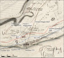
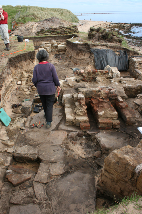
Excavations identified 3 buildings identified on the estate plans as well as an 'Intended Waggon Road' [see Site Record 11938]. Two of the buildings were comprehensively excavated. The ground plan of the buildings was almost identical. They measured 14.8m in length and 4.8m wide. A central wall divided the buildings into 2 large rooms. The dividing wall contained evidence of a central chimney with a fireplace opening into the east room and a more substantial hearth structure opening into the west room. The buildings were constructed with local sandstone, bonded with clay and harled with lime mortar. The hearths and chimneys were of brick. One of the buildings had a pantiled roof. In the other building, labelled the Salt Mans's House on Farey's 1813 map, ([see site record 11936] there was no evidence of roofing material. Historic documentation mentions turf roofs, so it was posssibly turf. It is probable that these buildings were multi-functional - with a salt pan on one side and accommodation, storage and drying room on the other. Only a fragment of the back wall of a third building survived, the rest of having been lost to erosion. However, it is depicted in the same way and with the same dimensions on the 1772 estate plan, and so is likely to have been very similar to the two excavated.
Two further buildings depicted on the 1772 plan nearest to the coast edge are now completely destroyed. Their location is now within the intertidal zone.
A rich artefact assemblage from the buildings included numerous domestic items including high status imported pottery and gin bottles, drinking glasses, animal bone, fish bone, very numerous Fe objects (mostly nails and fittings and fixtures from the buildings), and a pair of scissors.
Coastline regression using historic mapping showed that between 30 and 50m of coastline has been lost in the vicinity of the 18th century. Most of the historical loss occurred between 1772 and 1813. The current rate of loss, however, appears to be the most rapid yet documented.
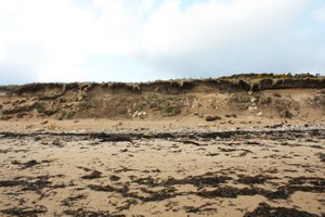
Although this site has been excavated, continued rapid erosion of the dune face here will almost certainly reveal additional evidence, and possbly uninvestgated buildings. The known buildings and intended Waggon Way are clearly visible in the dune face as layers of coal dust, stone walls, and brick and pantile debris.
Visited 2018 & 2019
As described, coast edge is eroding, structures and deposits remain vulnerable
Location
290365.00
903271.00
27700
58.0050659
-3.8568172
Submitted photographs
Image
Date
Caption
User
27/02/2015
Typical deposits in eroding 18th century salt pans: coaldust layers, mortar, walling, brick and tile
joannahambly
27/02/2015
General view of eroding section of 18th century salt pans, April 2013
joannahambly
27/02/2015
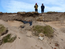
Area of dividing wall and hearths, Trench 4, Feb 2015
evelix
27/02/2015
Excavated dividing wall and chimney breast in eroding face of Trench 4, Nov 20143
joannahambly
27/02/2015
General view, eroding coastline of 18th century salt pans, Nov 2013
joannahambly
27/02/2015
General view of eroding section at 18th century salt pans in 2009
joannahambly
27/02/2015
Fireplace in east room
joannahambly
27/02/2015
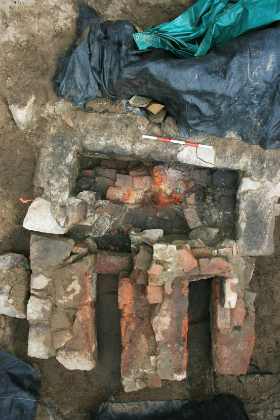
Salt pan hearth, Trench 4
joannahambly
27/02/2015
Building in Trench 4, 2008, looking west
joannahambly
27/02/2015
Excavation trenches overlain onto 1772 and 1813 mapping
joannahambly
27/02/2015
Plan of the building in Trench 4
joannahambly
27/02/2015
Trench 4 in 2008, brick hearth in foreground, looking east
joannahambly
Submitted updates
Update id
Date
User
3328
23/01/2019
EllieSCHARP
Description
Visited 2018 & 2019
As described, coast edge is eroding, structures and deposits remain vulnerable
1971
27/02/2015
joannahambly
Tidal state
Low
Site located?
Yes
Proximity to coast edge
Coast edge
Coastally eroding?
active sea erosion; has eroded in the past
Visibility above ground
Not visible
Visibility in section
Limited visibility in section
Access
accessible on foot (no footpath)
Local knowledge
is well known; has local associations/history
Description
Nothing visible as previous excavation by Clyne Heritage Society has been backfilled.
ShoreUPDATE comment:
This record refers to the whole site of the 18th century or 'New' Salt Pans in Brora. The SCAPE Trust with Clyne Heritage Society and local volunteers carried out substantial excavations on the site in 2007, 2008 and 2009. (Refer to Brora Back beach Data Structure reports 2007, 2008, 2009 for full details and wesite http://www.shorewatch.co.uk/brora).
Developed by John Williams for the Sutherland Estate in 1767, the Salt Pans only operated for a decade, closing in 1777.
They are depicted on estate maps of 1772 (Kirk) and 1813 (Farey).
Excavations identified 3 buildings identified on the estate plans as well as an 'Intended Waggon Road' [see Site Record 11938]. Two of the buildings were comprehensively excavated. The ground plan of the buildings was almost identical. They measured 14.8m in length and 4.8m wide. A central wall divided the buildings into 2 large rooms. The dividing wall contained evidence of a central chimney with a fireplace opening into the east room and a more substantial hearth structure opening into the west room. The buildings were constructed with local sandstone, bonded with clay and harled with lime mortar. The hearths and chimneys were of brick. One of the buildings had a pantiled roof. In the other building, labelled the Salt Mans's House on Farey's 1813 map, ([see site record 11936] there was no evidence of roofing material. Historic documentation mentions turf roofs, so it was posssibly turf. It is probable that these buildings were multi-functional - with a salt pan on one side and accommodation, storage and drying room on the other. Only a fragment of the back wall of a third building survived, the rest of having been lost to erosion. However, it is depicted in the same way and with the same dimensions on the 1772 estate plan, and so is likely to have been very similar to the two excavated.
Two further buildings depicted on the 1772 plan nearest to the coast edge are now completely destroyed. Their location is now within the intertidal zone.
A rich artefact assemblage from the buildings included numerous domestic items including high status imported pottery and gin bottles, drinking glasses, animal bone, fish bone, very numerous Fe objects (mostly nails and fittings and fixtures from the buildings), and a pair of scissors.
Coastline regression using historic mapping showed that between 30 and 50m of coastline has been lost in the vicinity of the 18th century. Most of the historical loss occurred between 1772 and 1813. The current rate of loss, however, appears to be the most rapid yet documented.
Although this site has been excavated, continued rapid erosion of the dune face here will almost certainly reveal additional evidence, and possbly uninvestgated buildings. The known buildings and intended Waggon Way are clearly visible in the dune face as layers of coal dust, stone walls, and brick and pantile debris.
Regular monitoring. Provision for rapid recording and investigation of additional material. Upgrade to Category 2.